
By : Bhavika Bhartiya, Research Analyst, GSDN
Discussions of wars usually revolve around weapons, soldiers, and technology. However, geography, which is the actual physical environment of any given country and the location of that country on the Earth’s surface, is often overlooked as a consideration in terms of a war outcome. An example is the conflict between Iran, on one side, and the United States & Israel, on the other side, which became more so in terms of confrontation in 2025, illustrated that Geography can provide a country significant advantages in warfare regardless of whether or not they are being confronted by combat superiority. The geography of Iran which includes mountains along its borders and a small seaward boundary and large expanse of land and its geographic location in the Middle East made it possible for Iran to create significant military challenges for the U.S. & Israeli forces during this conflict, thus holding their positions from both countries. This article will illustrate how geography played an essential role in helping Iran maintain its ground during these conflicts.
Iran’s Location: Sitting at the Centre of Everything
Iran is positioned at an important area in the globe. It shares borders with Afghanistan, Armenia, Azerbaijan, Iraq, Pakistan, Turkmenistan and Turkey. To the south Iran has a long coastline along the Persian Gulf (or Arabian Gulf) and to the north it has a coastline along the Caspian Sea. Iran’s central location makes it very difficult for Iran to be cut off from other countries (surrounded by its enemies).
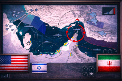
During this period of conflict, the most critical geographic position Iran held was that of the Strait of Hormuz – a very narrow body of water through which at least 20% of the world’s oil flows daily. Because Iran shares a border with the Strait of Hormuz, it had the capability to threaten oil ships traveling through the Strait. This caused the price of oil to increase around the world and put considerable tension on any country that relied on foreign oil from the Gulf. As a result, both the US and Israel had to carefully consider how far either country could push Iran, knowing that Iran could disrupt global energy supplies simply because of its geographic position.
The Mountains: Iran’s Protective Shield
Iran’s two biggest mountain ranges served as its primary defence during the war. The Zagros Mountains form the western and southwestern borders with Iraq while the Alborz Mountains run in the north of Iran. These mountains are very large and steep, making it difficult to pass through them.
If the U.S. were to have sent ground troop into Iran from Iraq, they would have had to navigate through the Zagros mountain passes. Moving heavy military equipment and vehicles through narrow roads would be slow, risky, and expensive. The Iranian Revolutionary Guard Corps (IRGC) have extensive knowledge about these mountains and have been preparing for years how to defend this area of their country. During the Iran-Iraq War of 1980 to 1988, Iran successfully resisted a well-armed Iraqi invasion partially due to these same mountains.
The mountains also offer protection to Iran’s nuclear facilities. For example, Iran’s Fordow enrichment site is located near the city of Qom inside a mountain at least 80m below ground. With some of the most powerful weapons the U.S. possesses, it would be very difficult for them to eliminate the Fordow facility with one strike, which gives Iran additional time to relocate any operational equipment or personnel to ensure they can continue developing their nuclear programme.
Iran’s Strategic Depth
Iran is a huge country around 1.6 million kilometres and, therefore, it has what some military experts refer to as “strategic depth.” This is important because the more area that you have to withstand damage, the longer it will take for an adversary to actually defeat your country. This is in stark contrast to Israel, which is one of the smallest countries in the world and most of its cities, airports and military infrastructure are crammed into a small strip of land along the coastline. Therefore, Israel is much more vulnerable to missile and/or drone attacks because there is virtually no strategic depth.
Iran has taken advantage of its size. Instead of deploying all its missiles and weapons in one location, it has deployed them over a vast area of the country (from the north-east corner of Khorasan Province to the south-west corner of Khuzestan Province). To achieve this, the IRGC (Islamic Revolutionary Guards Corps) has built underground tunnel systems in the mountains near cities such as Tabriz and Isfahan where missiles are stored and launched. While US and Israeli aircraft could potentially destroy some of these sites with missiles or other munitions, they would not be able to destroy all of them at once because they are located across such a vast area.
Partners Support in Tough Land: Stretching Iran Further
Iran did not engage in combat alone but had long established ties to militant groups in neighbouring countries, namely Hezbollah of Lebanon and the Houthi movement in Yemen as well as militias in Iraq and Syria. Collectively, these entities have been denoted by the “Axis of Resistance.” Each of these organizations have been geographically positioned in areas that present challenges to Americans and Israelis wishing to strike them.
For example, Hezbollah fires rockets from rural areas in southern Lebanon, forcing Israel to split its attention between both the Lebanese front and the Iranian front. Similarly, the Houthis launch both rockets and drones from among the most difficult areas available on the Arabian Peninsula, providing them with both physical barriers as well as geographic distance from their targets. The US Navy has spent hundreds of millions of dollars to shoot down these relatively inexpensive Houthi drones with interceptor missiles. The cost of a Houthi drone is about $20,000 to $30,000 while an interceptor missile costs the US about $2 million. The US will continue to spend huge amounts of money, and the difference in costs was clearly a benefit to Iran due to the distance and hiding place of the Houthis in the mountains.
The North: A Strong and Protected Side
Iran’s northern border with the Caspian Sea also helped it during the conflict. The Caspian is a landlocked sea, which states that the powerful US Navy could not sail into it. Russia, which also borders the Caspian, had a broadly affability toward Iran. This meant the US and Israel, both could not attack Iran from the north, and they could not fly over Russian airspace to reach Iran more easily. All their aircraft had to approach from the south and southwest, which were exactly the directions where Iran had built its strongest air defences and radar systems.
The northern border of Iran with the Caspian Sea also assisted Iran throughout the course of the war. Being that the Caspian Sea is a landlocked body of water, there was no way that the U.S. Navy could enter the Caspian Sea. Additionally, because of Russia’s relative friendliness towards Iran, neither U.S. nor Israeli forces could fly over Russian airspace enroute to attacking. Thus, having to use the southern/southwestern air routes provided lower air flow and had to approach at a much more stable and predictable altitude than would have been the case had they been able to operate from their respective bases from within Iranian territory.
Messages forwarding under the soil
War today involves much more than simply missiles and aircraft. Communication plays an equally important role in conducting warfare. Iran had been constructing a comprehensive underground fibre optic cable network throughout its entire territory and has sufficient underground military commander sites that they are hard to destroy via air attack. In fact, many of Iran’s civilian communications were able to be disrupted due to US cyber-attacks, but the military commander’s ground networks remained functional due to Iran’s mountainous terrain and large land mass. Once again, the geography of Iran’s large mountainous and land mass allowed it to be protected from the destructiveness of any technology by itself.
Conclusion
The conflict between Iran and the alliance between the United States and Israel demonstrated a critical lesson to all people that geographic territory continues to have major importance within modern warfare. Iran’s location along the Persian Gulf, as well as its mountain ranges, large size, unsatisfactory occupation of other countries by Iranian allied militias over considerable distances, and its security along its northern border provided Iran with an advantage that could not be easily disrupted by missiles and bombs. Further, while Iran was able to cause significant damage (the destruction of several major cities, damage to the Iranian economy and destruction to some of its military installations), Iran never lost. Geography plays a significant role in this equation. As a result, both sides of the conflict were forced into negotiations to reach a ceasefire, not because there was equal balance of power between Iran and the United States or Israel with respect to technology and resources, but because geography benefited the Iranian side of the conflict.
